WHEN WILL ASSAM SEE A PERMANENT SOLUTION TO FLOODS ?
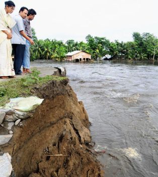
Every year in Assam the floods leave a trail of destruction, washing away villages, submerging paddy fields, drowning livestock, besides causing loss of human life and property in billions. The recurrence of flood and erosion continued to be the burning problem of Assam. The Brahmaputra and the Barak are the main two rivers, which cause major problems during the monsoon period every year in the shape of floods, bank erosion and drainage congestion. In fact, the successive waves of devastating floods in almost every year have virtually destroyed the economy, more particularly, the rural economy of the State.
Flood
waters also inundate vast tracts of forest land in most of the national parks
and wildlife sanctuaries, including the world heritage sites - Kaziranga
National Park and Manas Tiger Reserve. Tea gardens, particularly in the Barak
valley in southern Assam, have been hit hard by the floods which caused at least
seven of them to close down while others are on the verge of closure.
In Assam, the flood and erosion cause enormous damages in the crops,
livestock, land, property and bring untold miseries of the people at large. The
National Flood Commission had estimated the area vulnerable to floods in Assam
at 31.60 lakh hectares against 335.16 lakh hectares for whole India. Assam thus
accounts for 9.4 per cent of total flood prone area of the country. Due to flood
problem, the State has not been able to achieve the desired progress and
prosperity in spite of having vast natural resources. During the year 2002, a
total of 674.148 hectares of area were affected by floods resulting in heavy
damages, the value of which is estimated at Rs 18,678.60 lakh .
Almost entire Assam get submerged twice or thrice yearly due to flood resulting loss of life and property. Flood causes severe damage to ecology, environment. Hundreds of wild animal including deers and rhinoceros' calves living in the Kaziranga National Park loss their lives in the stream of Brahmaputra every year due to flood. The river island 'Majuli' is loosing several hectares of land to the water of Brahmaputra every year, thus the very existence of the island is under threat. The major cities and town including Guwahati get submerged during flood and the municipal and other waste spread over the land causing several health hazards.
The river Brahmaputra
is one of the greatest environmental assets of North East India.
The Brahmaputra is one of the largest river systems of the world and its basin
is also among the most flood-prone. In the past six decades, Assam faced major
floods in 1954, 1962, 1972, 1977, 1984, 1988, 1998, 2002, 2004, and 2007. Almost
every year three or four waves of floods ravage the State.
Brahmaputra has become the river of sorrow .For Assam, the mighty Brahmaputra, though a life-giving river has become more synonymous with devastation than with prosperity. Also known as the ‘Burha Luit’. The. The 2,906 km long Brahmaputra is one of Asia's largest rivers. The Brahmaputra and the Barak are the main two rivers, which cause all problems during the monsoon. In fact, the successive waves of devastating floods in almost every year have virtually destroyed the agriculture based economy of the state.

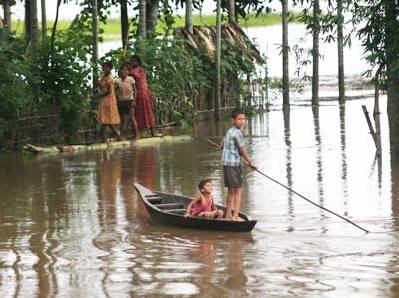
Majuli, Assam’s cultural capital and one of the largest river islands in the world, was among the worst hit, with virtually the entire island going under water every year. The Kamalabari-Auniati road in the island was breached at six places by the flood waters of the Brahmputra. Residents of many villages were marooned for days together. Other badly affected areas included Rangiya, Dhemaji, Lakhmipur, Dhakuakhana, Morigaon, Dhubri and Barpeta. Traffic on National Highway 31 remained disrupted following the road’s submergence at Kendukona in Rangiya subdivision of lower Assam’s Kamrup district.
According to 2001 census total population of Assam is 2, 66, 38, 407 and flood displaced
are
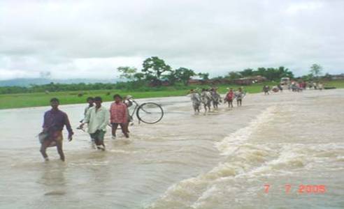
more then one third of the total population. There are reports of breaches in
embankments in 60 places. Flash flood partially damaged National Highway (NH) 31
and 52 and posed a threat to state's main life line NH 37 by eroding basement
area of an important bridge in Golaghat district. Heavy traffics have been
diverted through a gravel road. The recurrence of flood and erosion continued to
be the major obstacle towards development of Assam for decades. Floods in
Assam cause huge destruction and irreparable loss to the state's economy which
is largely agrarian. It also takes away the nutrient rich top soil, even after
the flood waters recede and leaves behind many problems for the health as well
as civic authorities. Malaria, Cholera and other disease appear causing a heavy
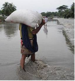
loss of life. Most of the damage is caused in the rural areas leaving the people
poorer and starving.
.
In one of the worst floods in living memory in 1998 the level of submergence crossed all previous records. Out of Assam’s then existing 23 districts as many as 21 were affected in the most devastating flood which caused the death of 105 persons, loss of 7814 cattle-heads, demolition of 30399 houses and complete destruction of standing crops on 288900 hectares of fertile land. The requirement of fund for relief, restoration and rehabilitation was put at Rs.1000 cores in a memorandum submitted by the Government of Assam (GOA) to the Government of India (GOI). The annual damages have increased since then.
One of the main causes of impoverishment of the rural areas of Assam has been the recurrent floods which result in the degradation of agricultural soil, loss of life and property and great suffering to the affected people. Several waves of flood every year leave behind great damage beside much misery and suffering
The main factors
causing extensive floods are the adverse physiographic of the region, heavy
rainfall, excessive sedimentation, frequent occurrence of earthquakes, hill/
land sliding, reduction of forest area and encroachment of the riverine area.
Usually Assam experience incessant rainfalls during the monsoon season, which
normally commence from the month of May and remain till mid October. Apart from
this, occurrence of floods in Assam has direct correlation with rainfall in the
catchments areas of neighbouring states of Arunachal Pradesh, Meghalaya, Mizoram,
Nagaland and the adjacent country of Bhutan.